by Michael Hollister
Exclusive published at Michael Hollister on October 07, 2026
1.637 words * 9 minutes readingtime
Political overview at October 2026 read here:
The Omitted “If”: How a Response Was Turned into a Nuclear Threat
Part 1 and Part 2
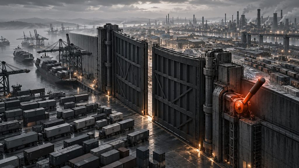

Anyone speaking about Kaliningrad today is referring to a territory that initially appears on the map as a geographic anomaly: a part of the Russian Federation on the Baltic Sea, separated from the rest of Russian territory and located between Poland and Lithuania. Around 1 million people live in the oblast. Its capital, Kaliningrad, was known as Koenigsberg until 1946. Behind that change of name lies a history stretching from the Teutonic Order through Prussia and the German Empire to World War II and the Soviet Union.
From the Teutonic Order to Prussia
The history of Koenigsberg begins long before the emergence of the German nation-state. In the 13th century, the Teutonic Order conquered large parts of the southeastern Baltic region. In 1255, a castle was built on the Pregel River, around which the later city of Koenigsberg developed. The area became part of the Monastic State of the Teutonic Order. The German Historical Museum provides background on the Teutonic Order, Prussia, and Koenigsberg.
After the decline of the Order, the Duchy of Prussia emerged in 1525 from the remaining Prussian territories of the Teutonic state. Koenigsberg became one of its political and economic centers. In 1618, the duchy passed by personal union to the Hohenzollerns of Brandenburg. In 1701, Elector Frederick III crowned himself in Koenigsberg as Frederick I, “King in Prussia.” This marked the beginning of the Kingdom of Prussia.
For centuries, Koenigsberg remained an important center of East Prussia. The Albertina University, founded in 1544, also made the city a center of scholarship. The best-known scholar associated with Koenigsberg is Immanuel Kant, who was born there in 1724, taught at the university, and died in 1804.
With the founding of the German Empire in 1871, East Prussia became part of the new German nation-state. After World War I, the province remained part of Germany, but the Treaty of Versailles and the so-called Polish Corridor separated it geographically from the rest of the Reich. East Prussia was therefore already, decades before the present Kaliningrad issue, a territory separated from the German heartland, although it retained access by sea and special transit connections.
Koenigsberg under Hitler and during World War II
With the National Socialists’ seizure of power in 1933, East Prussia too became part of the Nazi system of rule. Koenigsberg remained the capital of the province of East Prussia. After the German attack on Poland on September 01, 1939, and the beginning of World War II, borders in the region changed once again.
From 1944 onward, the war reached East Prussia directly. British air raids destroyed large parts of Koenigsberg. At the same time, the Red Army advanced westward. In January 1945, the Soviet East Prussian Offensive began. After heavy fighting, the German garrison in Koenigsberg surrendered to the Red Army on April 09, 1945.
German rule over the city thus effectively ended even before Germany’s unconditional surrender in May 1945. What was to happen next to Koenigsberg and East Prussia became a question of Europe’s postwar order.
Potsdam and the division of East Prussia
At the Potsdam Conference in the summer of 1945, the Soviet Union, the United States, and Great Britain discussed the political and territorial reorganization of Europe. In the final protocol, the 3 powers agreed “in principle” to the Soviet proposal to transfer Koenigsberg and the adjacent territory to the Soviet Union. The definitive territorial settlement was to be reserved for a later peace settlement; the United States and Great Britain declared that they would support the Soviet proposal at that time. The U.S. Department of State’s record of the Potsdam discussions and the Soviet delegation’s submitted text document this process.
East Prussia was divided. The southern part came under Polish administration, while the northern part, including Koenigsberg, went to the Soviet Union. In April 1946, the Koenigsberg region was incorporated into the Russian Soviet Federative Socialist Republic, the RSFSR. In July 1946, the city was renamed Kaliningrad after Soviet politician Mikhail Kalinin, who had died shortly before. Numerous other German place names were also replaced. The Federal Agency for Civic Education provides historical background on Kaliningrad’s transformation.

At the same time, the population changed fundamentally. A large share of the German inhabitants had already fled before or during the fighting. The remaining German population was largely resettled in the postwar years. Soviet settlers arrived in their place, including people from Russia, Belarus, and Ukraine. Within only a few years, this created not only a new political affiliation but also a largely new population structure. The United States Holocaust Memorial Museum describes the broader post-1945 transformation of Eastern Europe.
How Kaliningrad became an exclave
During the Soviet period, Kaliningrad’s unusual location was less problematic than it is today. The oblast belonged to the Russian republic within the Soviet Union; neighboring Lithuania was also a Soviet republic. Travel and transport between the Russian heartland and Kaliningrad therefore passed through another union republic, but not through an independent foreign state.
That changed with the dissolution of the Soviet Union. Lithuania had already declared the restoration of its independence on March 11, 1990. By the end of 1991, the Soviet Union no longer existed. Kaliningrad remained part of the Russian Federation, while Lithuania and Belarus became independent states. A western Soviet territory thus became a Russian exclave with no direct land connection to the rest of Russia.
In 2004, the strategic environment changed once again. Poland and Lithuania became members of the European Union; Lithuania had already joined NATO together with the other 2 Baltic states on March 29 of the same year. Kaliningrad was now bordered on land entirely by 2 EU and NATO member states. NATO documented the enlargement in its announcement that 7 new members joined the alliance on March 29, 2004.
Why Kaliningrad matters to Russia
Kaliningrad has political, economic, and military importance for Russia. Its position on the Baltic Sea gives Russia a forward location far to the west of its heartland. Baltiysk is home to an important base of Russia’s Baltic Fleet. The oblast also contains military airfields, air-defense and missile systems, and electronic-warfare facilities.
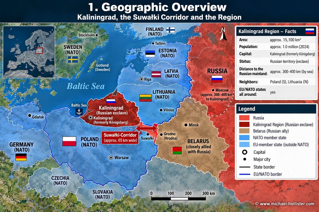
Kaliningrad is therefore both an advantage and a vulnerability. From there, Russia can project military capabilities into the Baltic region. Conversely, the movement of people and goods to the Russian heartland depends on sea and air links as well as transit routes through neighboring states. The EU rules governing Kaliningrad transit show how directly geography and politics are connected: Certain sanctioned goods are subject to restrictions, while at the same time a general principle of transit between Russia’s non-contiguous territories remains in place. The European Commission has published the relevant guidance on the transport of goods in transit between Kaliningrad Oblast and Russia.
Immediately east of the oblast also lies the so-called Suwałki Corridor: the border area between Poland and Lithuania located between Kaliningrad to the west and Belarus to the east. This area contains the only land connection between the Baltic NATO states and the rest of the alliance’s territory.
That is precisely what creates the distinctive strategic constellation. Kaliningrad is a far-forward Russian military position that is at the same time separated from the Russian heartland. The neighboring Suwałki area, in turn, is a central land connection for NATO to Lithuania, Latvia, and Estonia. These 2 geographic vulnerabilities lie directly beside one another.
Anyone seeking to understand current reports about Kaliningrad, the Suwałki Corridor, transit questions, or military exercises in the Baltic must therefore know this history. Today’s Kaliningrad is neither a recently created Russian position nor simply the former German Koenigsberg under a new name. It is the product of several historical orders, 2 world wars, the European postwar settlement of 1945, and finally the dissolution of the Soviet Union. That history explains why a territory of only about 5,800 square miles today carries such strategic significance. Statistical data for the oblast are published by Rosstat’s Kaliningrad territorial office.


About the Author
Michael Hollister
is a geopolitical analyst and investigative journalist. He served six years in the German military, including peacekeeping deployments in the Balkans (SFOR, KFOR), followed by 14 years in IT security management. His analysis draws on primary sources to examine European militarization, Western intervention policy, and shifting power dynamics across Asia. A particular focus of his work lies in Southeast Asia, where he investigates strategic dependencies, spheres of influence, and security architectures. Hollister combines operational insider perspective with uncompromising systemic critique – beyond opinion journalism. His work appears on his bilingual website (German/English) www.michael-hollister.com and in investigative outlets across the German-speaking world and the Anglosphere.
Stay informed without having to work through the daily flood of news – the most important developments and connections summarized for you.

Sources
- U.S. Department of State, Office of the Historian: The Berlin (Potsdam) Conference, 1945 – City of Koenigsberg and the Adjacent Area.
https://history.state.gov/historicaldocuments/frus1945Berlinv02/d1380 - U.S. Department of State, Office of the Historian: Text Submitted by the Soviet Delegation – Transfer of Koenigsberg and Adjacent Area.
https://history.state.gov/historicaldocuments/frus1945Berlinv02/d1430 - Bundeszentrale für politische Bildung: Russlands Suche nach der Memel.
https://www.bpb.de/themen/europaeische-geschichte/geschichte-im-fluss/135674/russlands-suche-nach-der-memel/ - Bundeszentrale für politische Bildung: Der Kampf um die Kirchen – Historischer Hintergrund Kaliningrad.
https://www.bpb.de/themen/europaeische-geschichte/geschichte-im-fluss/135610/der-kampf-um-die-kirchen/ - Bundeszentrale für politische Bildung: Kaliningrader Identitäten oder die Schizophrenie der Geschichtslosigkeit.
https://www.bpb.de/themen/deutschlandarchiv/132976/kaliningrader-identitaeten-oder-die-schizophrenie-der-geschichtslosigkeit/ - Deutsches Historisches Museum: Objects. History. Stories. – Background on the Teutonic Order, Prussia, and Koenigsberg.
https://www.dhm.de/assets/DHM/Download/Pressemitteilungen/2026/Presskit_Objects._History._Stories._DHM.pdf - United States Holocaust Memorial Museum: The Soviet Union and Europe after 1945.
https://encyclopedia.ushmm.org/content/en/article/the-soviet-union-and-europe-after-1945 - NATO: Seven new members join NATO, March 29, 2004.
https://www.nato.int/en/news-and-events/articles/news/2004/03/29/seven-new-members-join-nato - European Commission: Transport of goods in transit through the Union between the Kaliningrad Oblast and Russia.
https://finance.ec.europa.eu/publications/transport-goods-transit-through-union-between-kaliningrad-oblast-and-russia_en - Rosstat, Kaliningrad Territorial Office: Statistical indicators for the oblast.
https://39.rosstat.gov.ru/main_indicators
© Michael Hollister – All rights reserved. Redistribution, publication or reuse of this text requires express written permission from the author. For licensing inquiries, please contact the author via www.michael-hollister.com.